
Automated Officer Tracking System
Real-Time Officer Location for MultiOp Dispatching
AOTS securely uses an officer's Android phone to provide MultiOp Dispatching with current field location information and historical tracking data — without requiring specialized GPS hardware installed in every vehicle.
AOTS follows the officer — not just the vehicle.
From Officer Phone to Dispatch Map
AOTS links a secure mobile location source to MultiOp Dispatching, keeping officer markers distinct from call markers throughout the operational view.
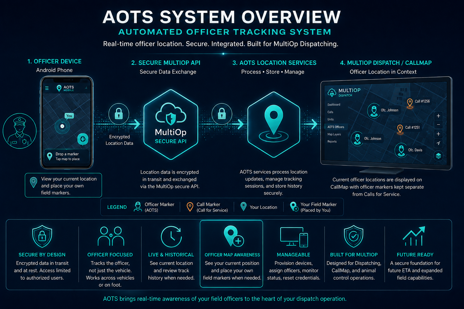
Click image to enlarge.
Officer Android Phone → Secure MultiOp API → AOTS Location Services → MultiOp Dispatch / CallMap. Officers can also see their own current location and place their own field markers from the device, while dispatch keeps officer markers visually separate from call markers.
Why Track the Officer?
Traditional vehicle tracking tells you where a vehicle is located. Animal control operations are often more complicated.
Officers may switch vehicles, ride together, work temporarily away from their vehicle, or operate in situations where the person — not the vehicle — is the resource dispatch needs to understand.
AOTS links location information directly to the assigned officer.
The officer remains the tracked operational resource, even when the vehicle changes.
How AOTS Works
A simple four-step flow connects an officer's device to MultiOp Dispatching.
See Officers on CallMap
Officer locations appear directly within MultiOp Dispatching and CallMap — alongside the calls your dispatchers are already managing.
AOTS gives Dispatch real-time field awareness by showing officers directly on the operational map. Officers and calls are visually distinct, so Dispatch can quickly understand what is happening in the field — where the officer is, where the call is, and how the situation relates geographically.
This is more than generic GPS tracking. It is integrated dispatch awareness, built into the same map view your team already uses every day.
Officer and call markers, shown together and never confused for one another.
Mark Important Locations in the Field
AOTS lets officers place persistent, purpose-specific map markers to document locations that matter during and after a field assignment.
Field officers often need to capture more than just their own location. Persistent map marks help document where something was found, seen, reported, or observed so that important locations remain visible for follow-up, review, and coordination.
Turn a GPS location into useful field intelligence.
Animal Sighting
Mark a location where an animal was observed, for follow-up or pattern tracking.
Trap Location
Document where a trap was set or is being monitored.
Evidence
Record the location of evidence relevant to a case for later reference.
Pickup Location
Note a location designated for an animal or item pickup.
Hazard
Flag a hazard that officers or the public should be aware of.
Example field marks from a patrol area.
Where the Officer Is. What the Officer Found.
Live Officer Awareness
See where the officer is right now, alongside the calls Dispatch is already managing.
Persistent Map Marks
See what the officer identified in the field, preserved for follow-up and coordination.
Officer Panic / Emergency Alert
Help protect field officers when every second matters.
AOTS gives field officers a dedicated emergency alert capability directly from their mobile device. With a deliberate press-and-hold action, an officer can immediately notify Dispatch that assistance may be needed.
Once activated, Dispatch receives a prominent emergency alert and can quickly identify the officer, view the officer's current or last-known location, acknowledge the alert, and continue monitoring the situation until it is cleared.
Press & hold to alert Dispatch
Officer device — emergency control
Dispatch — emergency alert & location
Officer Map Tools for Real Field Work
Officers can switch between Roadmap and Hybrid views, view live traffic, check Street View where available, lock the map north-up, re-center instantly on their own location, and view GPS accuracy and coordinates directly from the phone.
Roadmap + Hybrid
Choose the view that best fits the situation.
Street View
Inspect available street-level imagery directly from the officer map.
Traffic
View current traffic conditions when responding or traveling between locations.
North Only + Compass
Keep north at the top, or return to north-up with one tap.
Follow Me
Quickly return the map to the officer's current position.
GPS Location Details
See coordinates, GPS accuracy, and last location update; copy coordinates when needed.
Centralized AOTS Administration
AOTS Version 1 includes a web-based Administration Dashboard for managing the devices and assignments that support officer tracking.
Device Management
Review registered devices and device status.
Secure Provisioning
Provision approved Android devices for AOTS use.
Officer / Device Assignments
Associate devices with the officers who will use them.
Tracking Status
Review current device and tracking-session status.
Credential Management
Reset or reprovision device credentials when necessary.
Administrative Security
Administration access is protected using MultiOp's Windows/AdminOnly security approach.
Current Location and Track History
AOTS is designed to provide more than a current point on a map.
Historical location information can be retained as part of a tracking session, allowing authorized users to review where an officer traveled during field operations when operational review is needed.
Review the Route
Review an officer's route during a tracking session.
Operational Questions
Help answer operational questions after an event.
Historical Context
Provide historical context for field activity.
Supervisor Review
Support supervisor review and accountability.
Designed Around Animal Control Field Operations
Generic location-sharing applications can show a dot on a map. AOTS is being developed as part of a complete animal control operational system.
Officer location can exist alongside Dispatching, Calls for Service, welfare-related workflows, field operations, and other MultiOp capabilities.
Dispatching
Officer location alongside calls for service, unit status, and field response.
Explore Dispatching →Calls for Service
Officer markers stay distinct from complaint and incident markers.
Explore Call Handling →CallMap
Current officer location becomes part of the same operational map used for dispatch.
Explore Mapping →Officer Safety / Welfare
Location awareness alongside MultiOp's existing officer welfare monitoring.
Explore Welfare Checks →Field Operations
Location context alongside the same records officers use in the field.
Explore Field Operations →Use the Device Officers Already Carry
AOTS uses a supported Android phone as the field tracking device, reducing the need for dedicated GPS tracking hardware installed permanently in each vehicle.
Controlled and Manageable
AOTS is designed around managed devices, defined officer assignments, active tracking sessions, and administrative control.
Authorized administrators can manage which devices participate in the system and how they are assigned.
A Platform for Future Field Capabilities
AOTS Version 1 establishes the secure officer-location platform needed for additional MultiOp field capabilities.
Future development can build on this foundation with functionality such as expanded ETA support and deeper mobile dispatch integration.
Bring Live Officer Location Into Your Dispatch Operation
If your agency uses MultiOp Dispatching and would like to learn how AOTS can add officer-specific field location to your operation, we would be glad to discuss it.